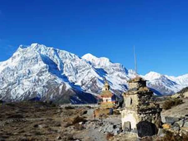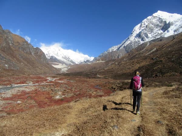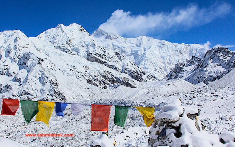

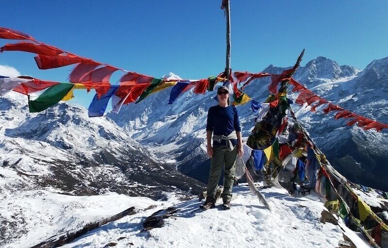
Mt.Kangchenjunga range viewing from Goecha la - 8586 m
The Goecha La trek in Sikkim is a highest mountain pass a naturalist's paradise and a pleasing destination shown as a crown of the Sikkim situated at Himalayan range in India. (Elevation (4,940m or 15,100ft) This is the summit from where everyone can able to viewed Mt. Kanchenjunga, the world's third highest mountain; Goechala Pass is dream, desire and amazing trekking destination that is loved by traveller to summit. It is not about Kanchenjunga alone can seen but the combination of other big summits around it makes Goecha la Trek an absolute adventure to many and it is a great pleasure to watch these summits from the landscapes filled with exotic flowers and immensely attractive meadows and forests. Goecha la trek offers the benefit of having experienced a truly spectacular alpine trek within a span of a week.
Trip Highlights
- Goechala the best trek in India amidst Big Mountains
- Highest mountain pass a naturalist's paradise and a pleasing destination
- Closest to viewed Mt. Kanchenjunga, the world's third highest mountain
- Landscapes filled with exotic flowers
- immensely attractive meadows and forestsBest season Trek to Goecha la :
- Trek duration : 10 Days
- Trek difficulty : Moderate-Difficult
- Trek Stile : Camping
- Minimum Age : From 20 to 50
- Max elevation : 4189m - to 15,100 ft up to Goechala view point 1
- Best season Trek to Goecha la :mountains are best visible in the months of March to May and from mid September to November
Trek Route
- Darjeeling - Yuksoom - Dzongri - Goecha la - Yuksoom - Gangtok - Bagdogra airport
Trek Base Camp
- Yuksoom is the base camp of Kanchanzonza Goecha la Trek It is located in a peaceful, cozy surrounding village covered by high green hills its natural beauty small, but beautiful village
Best season for Goechala Trek
Best season for Goechala Trek first season Spring (March to May) In the springtime, in the mountain the colorful flowers are blooming like rhododendrons,orchids and magnolia. during the fall, the skies are usually clearer the temperature ranges from 7 - 11 degrees C°, and the second Season is after the monsoon starting from (September to early December) the snow peaks show in their dazzling beauty in a clear blue sky when the temperature ranges from from - 10 to 4 degrees C°
How high and location trek route of Sikkim Kanchenjunga Goechala Trekt ?
The Sikkim Kanchenjunga Goechala Trek is a high mountain pass in Sikkim, India in the Himalaya range. The southeast face of Mt.Kanchenjunga, the world's third highest mountain, which runs about 90km altitude of 4,940 mt or 16,207 ft) the typical itinerary is over 9 days each day you will be walking about 6-7hours. the trek begin from Yuksoom trail thrugh kanchanzonga national park with night camping at Tshoka, Dzongri, Tsansing, Lamuney, Kockchurung end your trek Yuksom.
Goechala Trek Difficulty Level
Before signing up for the Goechala Trek, most people ask, how hard is the Goechala Trek? Of all the treks in Sikkim, the Goechala Trek is one of the more difficult ones. It is considered to be a hard trek. However, anyone with moderate trekking experience should have no problems taking this trek. If you do not have much prior trekking experience or if you want to be extra prepared, some cardio preparation would benefit you. In terms of altitude, you will not have to worry, as our ascent is slow and steady. For those of you who can take on this challenge, you will be heavily rewarded with some of the best mountain views in India.
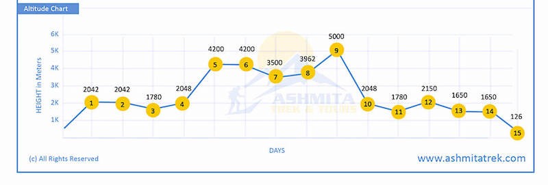
Sikkim Goecha la Trek altitude chart Map
Essential Information
.jpg)
The Sikkim Singalila Uttaray Round Trek the opportunity of viewing Mount Everest – Kanchenjunganot and many more..This new trek route falls entirely within Sikkim. We begin in the small village of Uttareyand trek to Chiwabhanjang on the Singalila ridge to continue on to Goechala. Opened as recently as the year 2000, this trail is not much frequented by trekkers. There are sections of narrow paths, ups and downs and some scree walking but for the most part, the trek follows a good path used mainly by yak herders in Sikkim.
On this wilderness trail, we walk up towards what is actually the border between Nepal, Sikkim and West Bengal. Dotted with beautiful high altitude lakes and passing several passes, this trek gives the opportunity of viewing Mount Everest – Kanchenjunganot and many more.. Only once at a specific high point but several times over the days as you cross the passes. This trail finally joins with the main west Sikkim trekking trail at Dzongri where the option is to continue to Goechala - the final view point where the left shoulder of Kanchenjunga stands just 9km away as the crow flies OR descend to Yuksom for those with time limitations. The advantage of this trek is that it is a round trip. Still a relatively new trek, the Sikkim Ridge trek promises to be among the best with its crowning glory of Kanchenjunga seen from several vantage points along this trek!
Trip Highlights
- Walking on the singalila ridge
- High altitude samiti holy lakes elevation o 4250 meter
- Spectacular views of Kanchenjunga, Everest, Makalu
- Unsurpassed views of Kanchenjunga range of mountains
- Trekking through Wildlife forest and Sanctuary
- Trek through the verdant meadows and dense forests
- Goechala the best trek in India amidst Big Mountains.
- View with Unique landscape
- Trek duration : 19 Days
- Trek difficulty : Moderate - Difficult
- Trek Stile: Camping
- Minimum Age : From 20 to 50
- Max elevation : 4189m - to 15,100 ft up to Goechala view point 1
- Best season Trek to Singalila Uttarey mountains are best visible in the months of March - May and mid September to November
Best season for Singalila Uttaray Trek
Best season for Singalila Uttaray Trek first season Spring (March to May) In the springtime, in the mountain the colorful flowers are blooming like rhododendrons,orchids and magnolia. during the fall, the skies are usually clearer the temperature ranges from 7 - 11 degrees C°, and the second Season is after the monsoon starting from (September to early December) the snow peaks show in their dazzling beauty in a clear blue sky when the temperature ranges from from - 10 to 4 degrees C°
Trek Route
- Bagdogra - Darjeeling - Uttarey - Dzongri - Goecha la - Yuksoom - Gangtok - Bagdogra airport
Base Camp
- Uttarey is The Base Camp of Singalila Ridge Round Trek is a Small village beautiful and a virgin paradise on earth set amidst the pristine valley. interested in peace and tranquility
Singalila Uttaray Round Trek altitude chart Map
.jpg)
.jpeg)
Join Himalyan Glaicer's View of Mt. Kanchendzonga Trek also known as Sikkim Kasturi - Labdang - Goechala Round Trek is a circuit trek starts from Yaksum that goes beyond the goecha la pass trek and ends your trek at Tasiding.This trek offer you the extraordinarily mountain views of Mt. kabru, Ratong and Kanchenjunga you can see clearly on the way to Dzongri Summit. In order to avoid the same trial we combined Kasturi Itinerary to go another route via Thansing with another trial move off the beautiful remote village Lampokhari has a small lake.This trek will end at the secret Tashiding gompa including cultural.
Trip Highlights
- This trek offer you the extraordinarily mountain views of Mt. kabru, Ratong and Kanchenjunga you can see clearly on the way to Dzongri Summit
- Stand at the top of Goechala (5,002 meters) with eye-popping mountain views Kanchanzonza
- Enjoy a range of sceneries throughout the trek
- The trekking thrudht rhododendron forests on the trail
- Up-close views of Kanchenjunga, the third highest mountain in the world
- Trek duration : 16 Days
- Trek difficulty : Moderate-Difficult
- Trek Stile : Camping
- Minimum Age : From 20 to 50
- Max elevation : 4189m - to 15,100 ft up to Goechala view point 1
Best season Trek to Sikkim Kasturi - Labdang - Goechala Round Trek : mountains are best visible in the months of March to May and from mid September to November
Trek Route : Bagdora - Darjeeling - Yuksoom - Dzongri - Goecha la - Tashiding - Gangtok - Bagdogra airport
Base Camp: Yuksoom is the base camp of Kanchanzonza Goecha la Trek It is located in a peaceful, cozy surrounding village covered by high green hills its natural beauty small, but beautiful village.
Packing List : Please look at the packing list for details to be carried during your trip
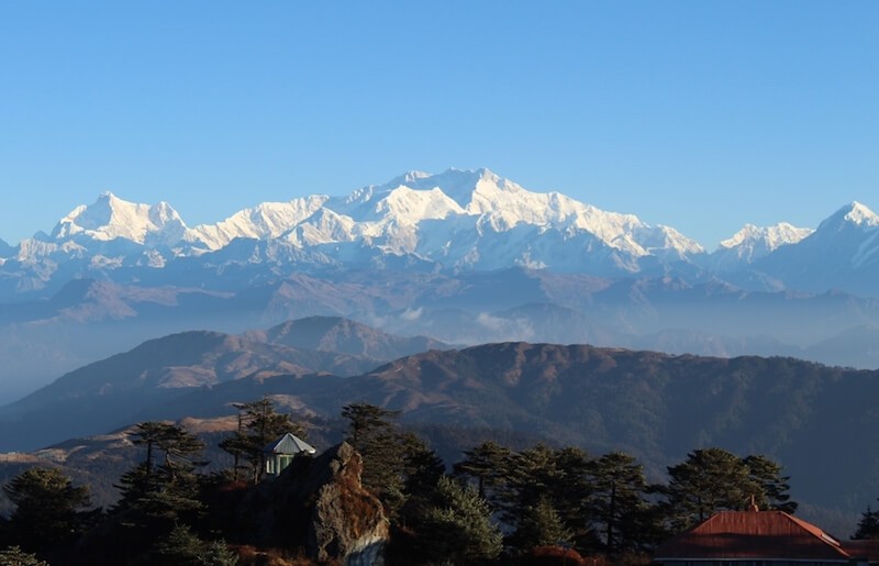
TheDarjeeling Singalila Ridge Trek! Just two hours from the city, the wonderful path begins. Though not a far drive from the city, the trail seems like it is in the middle of nowhere, as you traverse from ridge to ridge. The scenic Singalila Ridge connects the grand Himalaya of Nepal to India.The highlight of the trek is walking this ridge to Sandakphu (3636 meters/11,929 feet), the highest point in West Bengal, where you get jaw-dropping views of the highest peaks on the planet.
Rise from your peaceful slumber at Sandakphu and make a short climb to a viewpoint. From here, see Mount Everest (8848 meters), Kanchenjunga (8586 meters), Lhotse (8516 meters), and Makalu (8481 meters) in all their glory. It is truly one of the best, if not the best mountain view in India. Where else can you see 4 of the 5 highest peaks in the world in one sweeping view.
Trip Highlights
- Trekking through Singalila Wildlife forest and Sanctuary
- The trek through verdant dense forests and glimpses of the Sleeping Buddha
- Unique landscape during your trek
- Trekking in between Nepal and India border
- Best sunrise and sunset view from Sandakphu - Phalut - and from Tumling
- Enjoy the view of the majestic unforgettable Singalila ridge which
- includes great Mt. Everest, Kanchenjunga, Makalu and Lhotse, all in a single stretch range
- Overall Darjeeling area has more than 400 species of birds
- Local mountain village and meet with local people
- Trek duration 9 days
- Trek difficulty : lebel 2 Easy and medium
- Accommodation type : Guest houses & Lodges
- Max elevation: 3,636m, Sandakphu
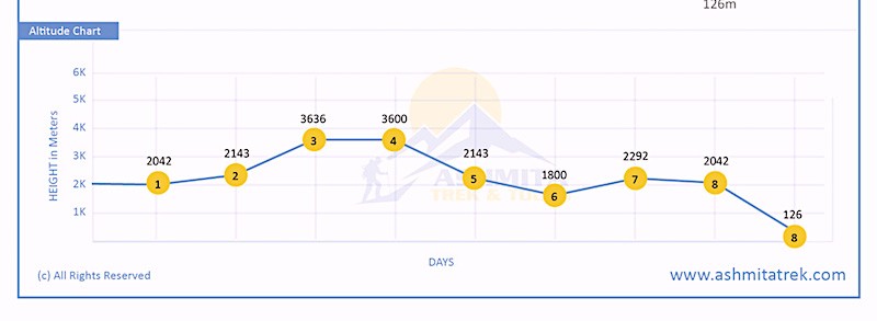
Singalila Ridge altitude chart Map
Singalila Ridge Trek Route
The trip route we have on package for 8 days start from Bagdora - Darjeeling - Tumling - Sandakphu - Phalut - Gorkhey - Timburey - Darjeeling - and finish at Bagdogra airport or optional you can choose only Trek part Darjeeling to darjeeling for 6 days.
Singalila Ridge Trek Base Camp
- Manebhanjyang is the get way to Sandakphu Singalila ridge trek the altitude of 2150m - 7,054 ft is small mountain village town covered by high green hills its natural beauty it's on Border of India and Nepal.
Useful Information
How high and location trek route of Singalila ridge trek?
The Singalila Ridge Trek is located on the north-south mountain Himalaya ridge which runs about 85km altitude of 3,636mt - 11,929ft along the India–Nepal and Sikkim border in Darjeeling the typical itinerary is over 6 days each day you will be walking about 6-7hours. the trek begin from Manevanjang trail thrugh national park then continues to Singalila Ridge with night at the beautiful village Tumling, Sandakphu, Phalut, Gorkhey and Timburey villages end your trek rimbeek and you drive to Darjeeling.
Darjeeling Singalila Ridge Trek difficulty ?
The Singalila Ridge Trek in Darjeeling is considered moderately difficult. The toughest portion is in the first couple of days when you ascend to the ridge. The trail climbs about 1500 meters in elevation in two days, which is a bit of a challenge. Also, for several days, you will be trekking and sleeping around the ridge, which lies above 3,636 meters (11,929 feet). Overall, if you have trekked before or if you are motivated, you should not have any issues with the Singalila Ridge Trek. It is suitable for people of all ages and experience levels.
Darjeeling Singalila Ridge Trek Permit ?
Yes, you need a permit for the Singalila Ridge Trek. The permit allows you to enter Singaila Ridge National Park. It can be obtained from the Forest Department in Manebhanjan or at the entrance of the park about 1 km from Tumling. The cost national park fee (200 INR per day per person and camara 100 INR ) is taken care of by Ashmita Trek and Tours.
Best seasons to visit Darjeeling - Singalila ridge Trek ?
Best season for Darjeeling Singalila ridge trek the first season Spring (March to May) In the springtime, the colorful flowers are blooming like rhododendrons,orchids and magnolia. during the fall, the skies are usually clearer the temperature ranges from 8 - 14 degrees C°, and the second Season is after the monsoon starting from 15th September to early December the snow peaks show in their dazzling beauty in a clear blue sky when the temperature ranges from from - 5 to 6 degrees C°
For those with little time and less inclination to undergo the rigours of hard mountain trekking, a trek up to the meadows of Dzongri Bigbari Trek in Sikkim will offer the benefits of having experienced a truly spectacular alpine trek within a span of a week (or even less). The trail runs through moss-laden forests of oak, chestnut, pine, maple, magnolia and rhododendron culminating in the meadows of Dzongri at 4,030 meters with exceptional mountain views. It is a naturalist's paradise. These forests harbor hundreds of varieties of wild plants, exotic orchids vie for attention with equally spectacular varieties of birds and butterflies.
Trip Highlights
- Dzongri the best trek in India amidst Big Mountains
- Highest mountain pass a naturalist's paradise and a pleasing destination
- Closest to viewed Mt. Kanchenjunga, the world's third highest mountain
- Landscapes filled with exotic flowers
- immensely attractive meadows and forests
- Visit Khecheopalri Lake is a sacred Lake for both Buddhists and Hindus at pelling
- Explore Pemayangtse Monastery in pelling (oldest and premier monasteries of Sikkim)
- Explore beautiful tea garden scenery along the way
- Trek duration : 11 Days
- Trek difficulty : Moderate
- Trek Stile : Camping
- Minimum Age : From 20 to 50
- Max elevation : 4200m - to 13779.53 ft up to Dzongri view point
Best season Sikkim Bikbari Dzongri Trek : mountains are best visible in the months of March to May and from mid September to November
Trek Route : Bagdora - Darjeeling - Yuksoom - Dzongri – Bigbari - Yuksoom - Gangtok - Bagdogra airport
Base Camp : Yuksoom is the base camp of Sikkim Bikbari Dzongri Trek It is located in a peaceful, cozy surrounding village covered by high green hills its natural beauty
Packing List : Please look at the packing list for details to be carried during your trip


.jpg)
.jpg)
.jpeg)


